A couple of months ago we flew south along the western slopes of the Sierras. In this posting, I'll be flying south again, but this time it will be along the east side of this awesome mountain range. There were two objectives on this flight: 1 to overfly the ghost town of Bodie, and 2, to fly south along the eastern Sierra's -- perhaps as far as Lone Pine.

On a southeasterly route from the foothills at Grass Valley we face rapidly rising terrain of the Sierra Nevada mountains. We climb to the VFR cruising altitude of 11,500' to clear several 10,000' peaks along our route. On our left, some 25 minutes into the flight, we fly near the South Lake Tahoe airport with the lake just behind. I failed to take a picture of Lake Tahoe this time as we passed, but here is a photo of the lake I took previously along the same route, albeit with a lot less snow.

And to the right of our path, we are looking south down the jagged spine of the Sierra Nevada mountain range. As far as I could see, it is just granite and snow covered granite.

Continuing on, we pass Alpine county airport (M45) where a fall camp out organized by RVer Paul Dye has been held for the last few years. Then, nearing Lake Topaz, I turn further south to follow a deep valley bordered by 11,000+ foot peaks. The valley widens at its far end and there sits the town of Bridgeport California. I planned to use the city to help me locate my first objective, the old mining town of Bodie. Years ago, Carol and I traveled to Bodie by automobile and I vaguely remember that it was just a little to the east of Bridgeport.
Founded in 1859, Bodie was a gold mining camp that eventually grew to 7000 residents by about 1875. Here is a photo of Bodie I found on Wiki, circa 1890. Today the town is a California state park visited by thousands during the summer, but by the looks of it, it does not seem accessible in the wintertime. The elevation is almost 8400 feet and the road leading in did not look like it was plowed.

Finding Bodie by air:
Once I arrived over Bridgeport, I turned east looking for the road that I had remembered leading to the ghost town. Unfortunately, I couldn't see the road or Bodie itself, for that matter. Bodie is not marked on the Garmin G3X moving map and I was beginning to think that I might not be able to spot the town with all the snow. It was right about then that Carol informed me that she had the town's location on the iPad. Curiously, the iPad app we use, Garmin Pilot, does include the town's location. The moving map in Garmin Pilot also has a nice feature called 'Track Vector' the draws a line out in front of the aircraft symbol to indicate where on the moving map the airplane will be in 5 minutes at the current rate. In the end, finding the town turned out to be a non-issue. I just had Carol tell me which way to turn the plane in order to center the track vector over the Bodie.
Founded in 1859, Bodie was a gold mining camp that eventually grew to 7000 residents by about 1875. Here is a photo of Bodie I found on Wiki, circa 1890. Today the town is a California state park visited by thousands during the summer, but by the looks of it, it does not seem accessible in the wintertime. The elevation is almost 8400 feet and the road leading in did not look like it was plowed.

Once I arrived over Bridgeport, I turned east looking for the road that I had remembered leading to the ghost town. Unfortunately, I couldn't see the road or Bodie itself, for that matter. Bodie is not marked on the Garmin G3X moving map and I was beginning to think that I might not be able to spot the town with all the snow. It was right about then that Carol informed me that she had the town's location on the iPad. Curiously, the iPad app we use, Garmin Pilot, does include the town's location. The moving map in Garmin Pilot also has a nice feature called 'Track Vector' the draws a line out in front of the aircraft symbol to indicate where on the moving map the airplane will be in 5 minutes at the current rate. In the end, finding the town turned out to be a non-issue. I just had Carol tell me which way to turn the plane in order to center the track vector over the Bodie.

I made several passes over the town and did not see any sign of people. I think that in the wintertime, Bodie actually is a ghost town.


Just to the south of Bodie lies Mono Lake. Mono is a very salty lake and is devoid of fish because of it. It does support brine shrimp, however, and it makes a nice picture.

Moving on, we decided to continue south to Mammoth airport (KMMH). This airport sits at the extreme west side of the valley parallel to highway 395 at the base of its namesake mountain. I snapped this picture on the ramp in front of the FBO, Hot Creek Aviation.

While we're here I might as well take on some very expensive fuel. I haven't had the chance to overpay for 100LL since we were in Eureka. I should have known better since there were a lot of expensive looking turboprops and some jets on the ramp.

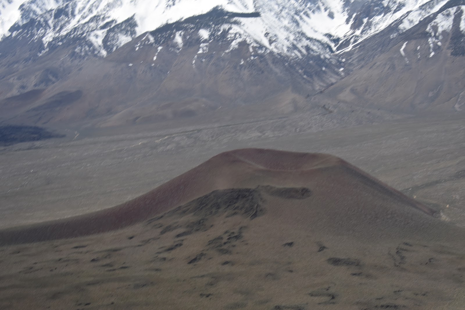
It was still early afternoon so we were off once again still heading south along the Sierras. Along the way, we spotted this interesting little cinder cone near Bishop.
About 50nm further and we arrive at our second objective, Lone Pine California. In the photo below, the transient parking area and the terminal building did not make it into the frame due to the unusually long taxiway (extending to the lower right).

When we finally made it to the ramp we found just one other aircraft in the parking area. As we were tying down, three occupants of that aircraft just returned from a walk into town. They had eaten lunch and had visited the Lone Pine Film History Museum. It turns out that a lot of movie westerns had been filmed in the Lone Pine area and they enthusiastically recommended the museum. Then they asked me where we had flown in from. I answered Grass Valley and then found out that they had come in from San Diego. A bit more chit chat and we were off to explore the airport.

The airport has a very old-timey feel to it. Looking close up, one sees rust and flaking paint everywhere. The pavement is weathered and a bit rough in places. Some might characterize the condition of this place as run down, but I prefer to think of it as authentic Americana. It's fun to imagine what this place might have been like when it was new. What one doesn't see are people. Once the other aircraft on the ramp departed, we had the place to ourselves.


A sign on the terminal building's door warned of steep fees and long wait times for after hours assistance with fueling. They helpfully listed about 5 people who would be willing to come out to the field, how long it would take them to get there, and how much the house call will cost you. I think the sign says it only applies to Jet A since there is self serve for 100LL. I especially enjoyed the ambiance enhancing bug collection on the window sill.

There is an open hangar near the entrance to the airport that included a pickup truck and 3 bicycles.

Looking closer we find that these bicycles are for visitor's use, courtesy of the Lone Pine Airport.


The question before us: Do we to walk into town for lunch or do we fly somewhere else where the food might be closer to the airport? With the discovery of the bicycles, the decision was made for us.
Carol's bike needed some adjustment, mainly to lower the seat. I had tools in the plane so this was no obstacle. After some wobbly circles in front of the hangar, Carol was ready to strike out for the big city of Lone Pine. She makes a point of informing me that this is her first bicycle ride in 35 years!

Along the one mile ride into town, I had this view of Mt. Whitney to the west. At 14,505', Whitney is the tallest peak in the lower 48 States.

After a few minute's ride, we found ourselves in downtown Lone Pine. We looked around a bit and finally selected a little diner called "The Grill" for lunch. The food was good and we were very hungry after that 7 minute ride.

A few more pictures like this and Carol will relieve me of picture taking duties for all time.

After lunch, we begin the ride back to the airport. At this point, Carol suffers a little riding incident. The proximal cause being her unpredictable and very low speed trajectory intersecting a small retaining wall. The resulting crash has her departing the bicycle perpendicular to the cycle's direction of travel at somewhat less than walking speed. In fairness to Carol, I should point out that this is Carol's first bicycle riding mishap in 35 years.
From my vantage point behind, the accident did not appear too serious. The first clue that I might be wrong about that was that she did not want to get up right away, but instead elected to recover for a couple of minutes before we continued our trek to the airport. Alas, she decided that she was done with riding and admitted that she was in some pain. Only later would we find out that it was more serious than we knew. We push the bikes all the way back.

By the time we arrive back at the airport, I am beginning to get the idea that Carol should seek some medical attention. Carol is not in favor and just wants to depart for home. I am thinking about the isolated nature of this town and judge the odds of getting a timely medical evaluation as vanishingly small. Grass Valley is a small community, but it is still an order of magnitude larger than Lone Pine. I rationalize that we could get a proper medical evaluation there more expeditiously, so I accede.

We return the bikes to the hangar and I then I quickly untie the aircraft. I don't want Carol to think that I am in a rush or that I am overly concerned about her crash, but I waste no time in getting back into the air. This is the view heading back to the runway along the unusually long taxiway.

As I am climbing out of the Lone Pine area I take this picture backward over my left shoulder through the back window at a very oblique angle. The reason I am including it here is that it shows the eastern slopes of the Sierras all the way to their end at the Mojave desert (upper left corner).

I flew up to the smoothest air I could find. First at 10,500' then 12,500'. I fly the reverse course of my trip down to Lone Pine as far as Mono Lake, by then I have sufficient altitude to fly a direct course diagonally across the Sierras toward Grass Valley.

I wouldn't ordinarily choose that course because of the really rough country below, but the air was smooth up here and I could shave a few minutes off of the time en route. The total time of the return trip was only an hour and forty minutes.
We make our arrival into Grass Valley and deplane. Just a few minutes after landing we are in the car heading in the direction of the emergency room. The hospital is right on our way home anyway. Just as I am about to turn into the hospital parking lot Carol decides that she would prefer to just go home. "We're right here", I answer. "Let's just go in and let them have a quick look."
Readers of 'Flying Magazine' will note their popular section called "I learned about flying from that." Each month a reader submits an article in which, as the result of some harrowing experience in flight, the author narrowly escapes death. Then the author admits to a series of mistakes or misjudgments that led to the issue.
Readers of 'Flying Magazine' will note their popular section called "I learned about flying from that." Each month a reader submits an article in which, as the result of some harrowing experience in flight, the author narrowly escapes death. Then the author admits to a series of mistakes or misjudgments that led to the issue.
"I learned about medical care from that"
5:40pm, Saturday evening.
5:40pm, Saturday evening.
When we arrived the waiting room was not even close to full. Good news for us, I think. There were two sick babies (and their tired looking mothers), a young man with a headache, a middle aged woman who clearly did not feel well, another woman with no obvious sickness or trauma, and Carol. We checked in and waited alongside the other five prospective patients for about two hours. One of the five got tired of waiting and just left. At 7:30 pm Carol was given a perfunctory exam by the triage nurse and then we were sent back to the waiting room. By 8:30 pm, Carol was admitted into the emergency room and was examined by the ER doctor shortly after. More waiting and then an X-ray. More waiting and a CT scan. Eventually, a diagnosis was proffered: Carol has a collapsed lung.
According to the doctor, the procedure to re-inflate the lung was simple: A tube would be inserted through the chest wall into the area next to the lung. The tube would allow the air that had leaked from the punctured lung to escape the chest cavity allowing the lung to re-inflate. Ten pm came and went and the 'simple' procedure had yet to be started.
Eons pass. Finally, the doctor did reappear and the insertion of the chest tube was completed in about 15 minutes. A new X-ray was ordered to check the tube's position. More waiting. Then we find out that the tube is not in the correct position. The doctor will need to re-position the tube.
Still more waiting, a new procedure, and a new X-ray. Wait some more. OK. She's good to go. On the way out we pass the now empty waiting room. It was now about 2:30 am as we were driving home. We had been at the hospital two hours longer than the entire round trip to Bodie and Lone Pine.
Our quick day trip that started out so well had turned into a grueling test of the patient's patience. Or was it the patient's husband's patience? Either way, during Carol's nine hour ordeal at the hospital, she received less than one hour of actual attention from the medical personnel. Where did the other 8 hours go? Since the ER was not at all busy and appeared to be very well staffed, I really don't know. Some of the waiting may have been caused by the ER doctor's steady stream of X-rays and the wait time for a radiologist to read them. I was too tired at the time to muster much anger at any of this -- not that it would have helped.
So the process of receiving medical care is none too pleasant we all agree, but what might I have done differently? Well, for starters, I think it unwise to encourage an inexperienced cyclist to make their first ride (in 35 years) so far from home. Second, at our age, we need to take falls more seriously. Since I'm not a doctor and my X-ray vision is not so good, I had no real way of knowing how serious Carol's condition might be. Finally, I assumed an unnecessary risk in taking her on board the aircraft where I would be unable to offer assistance were her condition to suddenly worsen. Or for that matter, whether the altitude changes or turbulence while flying might exacerbate her injury.
Ultimately, I am thankful that in the geologic fullness of time, Carol received the care that she needed. It seems that the Bard on Avon has it about right, All's well that ends well.
P.S. Carol was able to get the tube removed several days later and has fully recovered.