
Our plan was to depart at 9:00am. Sharp. No kidding, 9:00am. Really, that's when we're leaving. Needless to say, that didn't happen. Neither did 9:30am. If we can send a man to the moon... How come we can't leave on time? OK, that's a bit of a non sequitur, but it's a good thing because if a man's moon trip actually depended on us leaving on time... He won't be going.
Our initial route had us on a southeasterly heading. Cruising about 5500' we had a beautiful view of the western slopes of the Sierra Nevada mountain range that I had intended to follow pretty much all the way to Inyokern. About 45 minutes into the flight we were treated to this view of the entrance of the Yosemite valley.

The view off to the west was not so inviting. But why should I care? We weren't going over there. Or were we? It was about this time that I was informed of an issue in the passenger cabin. It seems that one of the passengers needed to use the facilities. Not a problem in an airliner, but in our two place airplane the nearest facilities were miles away. 26 miles in this particular case. The Garmin avionics make quick work of spelling out one's diversion options. Reedley airport was about the closest, but I wasn't sure if we could get down through the cloud layer once we got there. It turns out that Reedley was not overcast, just a broken layer and some mist to get through. Once we got close we could see the airport without difficulty from a few miles out.
 Reedley was typical of the small airports that dot the Sacramento valley. Surrounded by farmland on this lazy Saturday morning, Reedley was quiet and very nearly deserted. By comparison, Fresno, just a few miles to the northwest, is a bustling metropolis. Fortunately, there were facilities available. They were clean, and we were grateful. I spent a bit of time looking at my charts and just soaking in the quietness. I was hoping that by delaying our departure, the cloud layer above would dissipate. Here is a view to the southwest over the valley. Reedley is down there somewhere.
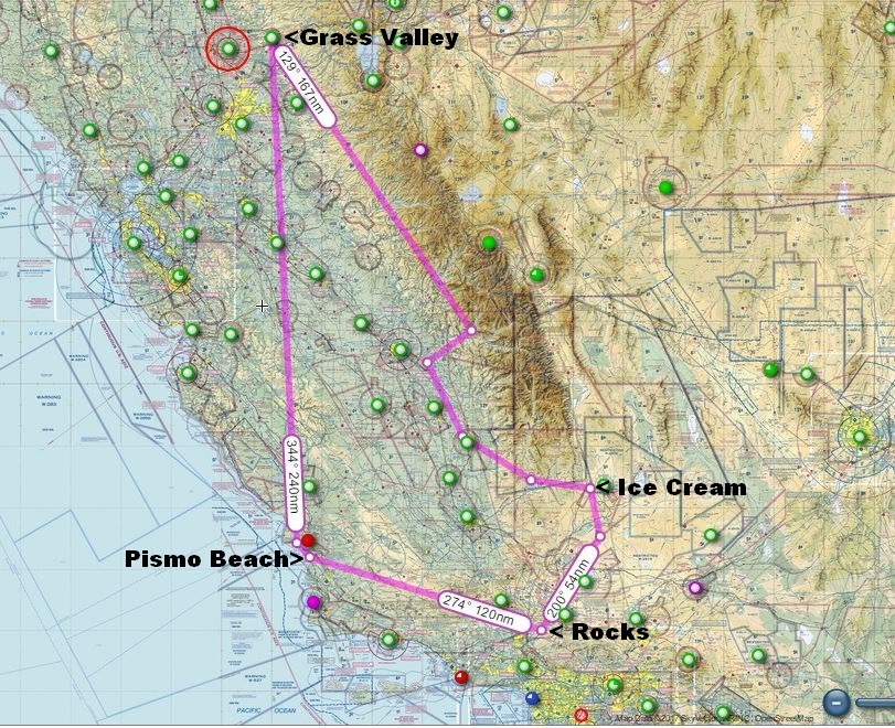
After some time it was apparent that the broken cloud layer wasn't going to clear up any time soon, so we decided to depart south towards Porterville staying just below the cloud layer. My plan was to get us closer to the ice cream and look for clearing weather. Fifteen minutes later we're at Porterville and the cloud layer is not looking any better. Time to turn left and head in an easterly direction towards Inyokern. As a VFR pilot, I am not allowed to fly through the clouds. In this situation, I must find a hole in the cloud layer to fly through. Since the sky was not completely overcast and it wasn't too difficult to find such a hole.
 |
| Isabella Lake, Kern Valley CA |
Presently, the clouds below give way to granite tipped mountains, our last barrier to ice cream. The RV-7A easily out climbs the rising slopes and we find ourselves crossing the Sierras at 9500 feet. Passing just north of Kern Valley airport we begin a slow descent that takes us south of Walker Pass at 5200' and then all the way down to the desert floor at Inyokern.
When we arrived the ice cream social was in full swing. There were about 20 RV aircraft already there and more arrived after us. We took the last parking space in the front row. The warm desert air was absolutely balmy, a welcome change from the cool dampness we left behind in Grass Valley. Our location at the end of the line granted the opportunity to see some really nice aircraft as we strolled the tarmac toward the gathered crowd.
At the terminal, several flavors of ice cream and all the fixings for cones and sundaes wait for us at the end of a short line. I had a bowl of vanilla and then I added some sprinkles on top just because I'm a wild man. Carol opted for a cupcake.
We milled about for a bit just watching the people happily chatting in various groups of three or four. In every direction, pilot's speak is overheard. The pilot's spoken language is two thirds English and one third acronym. On the ground, it is also partly visual. It is not hard at all to spot the right hand-as-airplane gestures that describe their airplane's curving path through the sky. And should a second plane enter the story, the left hand is ready and willing to fly as well. This is what pilots do when they are on the ground.

And so, once again, I failed to take enough photos to tell any kind of reasonable story. Here is the parking area with my plane at the far end, not visible, and too small to be seen in this shot anyway.

After about an hour or so of mingling, we thought it best to seek out our host, Alex, to thank him and his wife Alisha, for their hospitality and all the effort that goes into organizing something like this. It was still early in the afternoon, but there was still a lot of ground to cover. So we quickly refueled and we were on our way.
Our next destination was Vasquez rocks which Carol and I had visited by automobile in 2014. We thought it would be fun to see by air and it was. Unfortunately, I can't show you what it looked like because our camera was just out of reach in the baggage compartment. Alternately, both of us tried to reach the camera as I circled over the rocks all to no avail. It was awesome though, really it was.
The flight from Inyokern and Vasquez rocks was about 200 miles and allowed us to overfly Mojave airport, the birthplace of Spaceship 1 and 2. Our next stop was Pismo beach where we planned to walk the quiet sands and listen to the sounds of seagulls and the crashing surf. The reality turned out a bit different.
We landed at Oceano airport after a brief delay for skydivers. The Oceano airport is only about a block from the beach.


But first, we needed to get some food. As we were leaving the airport we happened across a gentleman who suggested several restaurants that were close by. We selected the Rock & Roll cafe which had been constructed out of two railroad cars. It had a 50's motif that seemed to fit and the food was very tasty.

It was only after we had thoroughly enjoyed our lunch and were on our way out, that I saw a mouse run by under the table next to me. I guess the mice know a good place too.
After our rather late lunch, we walked two blocks south to the ocean. It turns out that Pismo beach allows vehicle traffic to drive onto the beach. In addition, there were a variety of off road vehicles taking advantage of sand dunes a little further south. Our quiet walk on the beach will have to wait for a different venue.


After we had our fill of the ocean (which didn't take too long), we started back for the airport. At the entrance to the beach, there was assembled a great line of pickup trucks, mostly Chevys, waiting to gain access. It seems that this beach is also a cruising destination. It was Saturday night, after all.


Oceano Airport.

With the lengthening afternoon shadows, we turned our attention home still some 250 nautical miles distant. We blasted straight out of Oceano, flying the runway centerline out over Morro Bay and around the west side of San Luis Obispo Airport's airspace. Then we turned our little plane northeast for Grass Valley. To clear the coastal range, we made a comfortable climb to 7500'. Leaving the mountains behind and still cruising at 7500', I tuned in Nevada County Airport. It surprised me that still 175nm away I could hear an aircraft happily traversing our home airport's traffic pattern. The thought occurred to me to announce a 175 mile 45 for left downwind 25, but I just let it remain my little joke.
The sunset as we were just south of Sacramento, but in the fading light, I was able to capture this last photo. Folsom Lake in the foreground, Sacramento and the mostly flooded valley floor behind it, and finally, the coastal mountains in the far distance.

750 nautical miles flown, ice cream, rocks, lunch, a mouse, the ocean, and many great views of California. A great day.
Nice write up. It's great to be free and an American, isn't it?
ReplyDelete